INTRODUCING
BOOKINGS ON WIKICAMPS
Wye Creek Track
 Point of Interest
Description
This steep track follows the pipeline from the dam and leads you to the foot of a rock bluff. A further walk through beech forest takes you to the stream in the Lower Wye Creek basin.
4 hour advanced tramping track.
From the carpark by the Wye Creek Bridge, its a 45-min climb to the hydro dam. This steep, zig zag track follows the pipeline from the dam. Dont cross the dam, climb away from the creek the track leads to the foot of a rock bluff.
To reach the bush line and the Lower Wye Creek basin from the dam means another hour following a marked, benched track through beech forest. It then emerges beside the stream in the Lower Wye Creek basin.
Crosses private land.
The track offers rock climbing for all abilities on both sides of the creek, with climbs up to 50 m.
This is a high altitude walk and suitable for summer only, when snow may still be present. Be prepared for sudden weather changes.
No dogs.
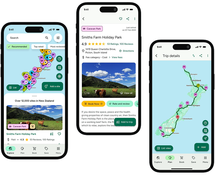
Find this site and more on WikiCamps
Take the ultimate camping companion on your next trip, with these great features:
![]() Explore more than 60,000 sites across New Zealand with detailed site information at your fingertips
Explore more than 60,000 sites across New Zealand with detailed site information at your fingertips
![]() Stay in the know with exclusive, insightful reviews from fellow travellers
Stay in the know with exclusive, insightful reviews from fellow travellers
![]() Map journeys, plan your route, and gauge your fuel spend with Trip Planner
Map journeys, plan your route, and gauge your fuel spend with Trip Planner
![]() No signal? No worries! Use offline mode to travel anywhere with WikiCamps
No signal? No worries! Use offline mode to travel anywhere with WikiCamps
![]() Add sites to your collections, search with intuitive filters, and so much more...
Add sites to your collections, search with intuitive filters, and so much more...
Get WikiCamps now!
Download WikiCamps from the App Store on your device.

