INTRODUCING
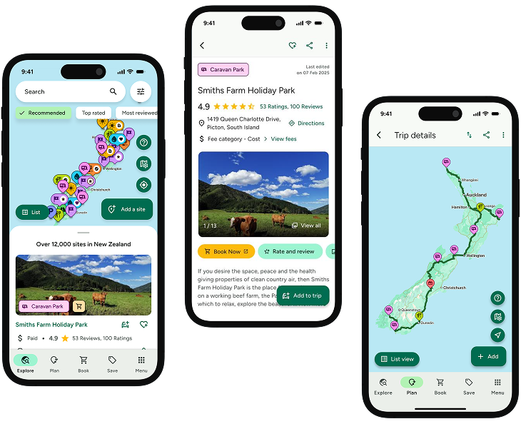
BOOKINGS ON WIKICAMPS
Lake Dumb-bell Route (Turn off)
 Point of Interest
Description
This marks the approximate point on the Tarnbrae/Te Araroa track to follow a lightly marked Route up to Lake Dumb-bell on top of the ridge.
Freehold Creek bushline to Dumb-bell Lake
Track category: Route
Time: 4 hr
Distance: 4 km
There is a lightly marked route in Freehold Creek basin to follow uphill. Travel past a tarn at 1479 m and climb up to the ridge. Sidle through the low part of the ridge between high points 1922 m and 1817 m. Head north to Lake Dumb-bell outlet.
Find this site and more on WikiCamps
Take the ultimate camping companion on your next trip, with these great features:
![]() Explore more than 60,000 sites across New Zealand with detailed site information at your fingertips
Explore more than 60,000 sites across New Zealand with detailed site information at your fingertips
![]() Stay in the know with exclusive, insightful reviews from fellow travellers
Stay in the know with exclusive, insightful reviews from fellow travellers
![]() Map journeys, plan your route, and gauge your fuel spend with Trip Planner
Map journeys, plan your route, and gauge your fuel spend with Trip Planner
![]() No signal? No worries! Use offline mode to travel anywhere with WikiCamps
No signal? No worries! Use offline mode to travel anywhere with WikiCamps
![]() Add sites to your collections, search with intuitive filters, and so much more...
Add sites to your collections, search with intuitive filters, and so much more...
Get WikiCamps now!
Download WikiCamps from the App Store on your device.

